Natural Resource Management
Grey County has a role to play in natural resource management. Our planning policies strive to protect natural areas, such as waterways, green spaces, forests and wetlands, and the plants and wildlife in our area. This includes reducing and preventing pollution and negative human activity. It also includes promoting environmentally friendly infrastructure and development.
Forestry Management
The Grey County Forest Management By-Law regulates tree harvesting and removal. It also promotes woodland preservation. Forest management by-laws regulate the clearing of forests, and sustainable harvesting. Forest management by-laws have existed in Ontario for 50 years. If you’re planning to harvest a forest or remove trees from a property in Grey County, you need to call or email before you cut. You may need a permit before you remove any trees.
Always call when cutting a tree in any of the following:
- In a forested area 1 hectare in size or larger
- Surrounded by:
- 1000 trees of any size
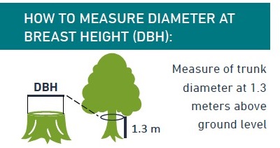
- 750 trees larger than 5 cm DBH
- 500 trees larger than 12 cm DBH
- 250 trees larger than 20 cm DBH
Someone looking to remove, injure or harvest a tree within one of these areas is required to:
- Get a permit
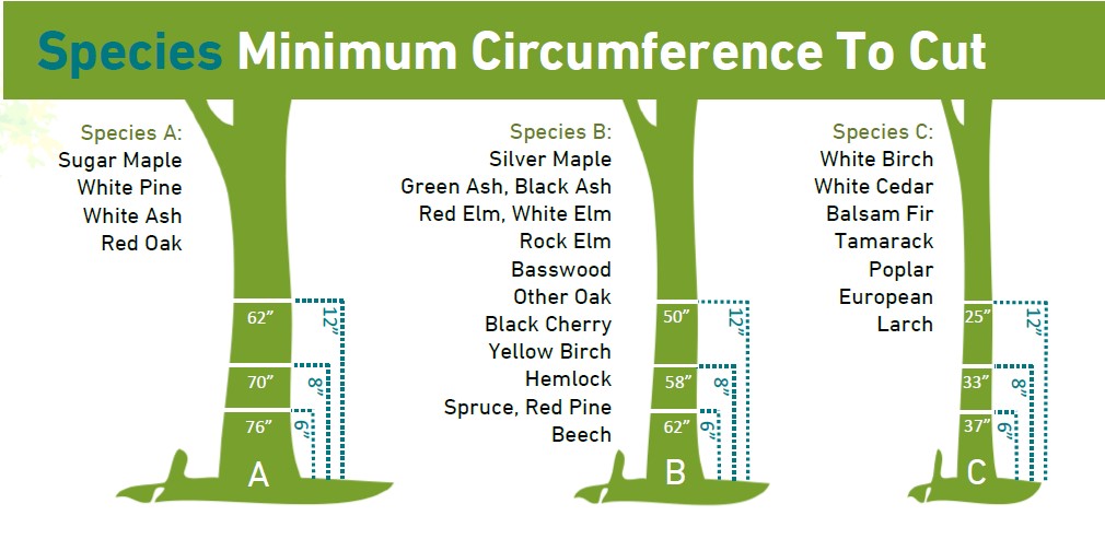
- Harvest or remove trees using good forestry practices, or within minimum circumference to cut guidelines
- Not cut trees smaller than those illustrated in the “Species Minimum Circumference to Cut” section
- Not decrease the average basal area of a woodland to less than 20 m2/Ha
- Not cut a tree in a conifer plantation
- Not cut a tree in a sensitive natural area
- Properly mark trees before removal
- Cut marked trees unless told otherwise
- Not harm a tree where unnecessary
- Not harm a tree by pushing it into a watercourse
- Give removal notice to neighbours
- Not cut trees to the point that the wood-land is no longer considered a woodland
Species minimum circumference to cut
How to measure diameter at breast height (DBH)

Common exemptions to this by-law include:
- Cutting for personal use (firewood)
- Cutting in accordance with an approved development application
- Cutting to provide utilities or a driveway where a building permit has been issued
- To prevent encroachment into existing agricultural production lands
Who to contact:
- 548-877-0720
- forests [at] grey.ca (forests[at]grey[dot]ca)
If you're planning on harvesting or cutting down trees in Grey County, complete the intent to cut form below.
The Forest Management Plan guides the management and activities allowed in forests owned by Grey County. The Plan was updated in March 2021 for a period of 20 years from March 2021 to December 2040. The Plan integrates the management of forests for “forestry purposes” as defined in the Forestry Act, the Provincial Policy Statement under the Planning Act, Niagara Escarpment Plan, Grey County Official Plan Land Use Policies, and other policies, guidelines, initiatives and documents.
- Provincial information on forest management and related links
Bruce Grey Woodlands Association
- Local workshops and courses through a peer network
Managed Forest Tax Incentive Program
- A provincial program which helps provide a reduction in property taxes on the forested portion of a property
Wildlife Management
Planning Ecology
The role of Grey County's planning ecologists is to review planning applications. Applications are reviewed with an environmental perspective. Ecologists make sure developments won't have a negative impact on natural features. They do this by considering technical studies about environment impacts and stormwater management. They also consider impacts to natural heritage. To be approved, developments must also meet other legislation such as the Provincial Policy statement, Grey County Official Plan, and municipal Official plans and policies.
Planning ecologists also contribute to County policy updates to help protect natural features.
If you have questions about natural heritage planning, please reach out to ecology [at] grey.ca (ecology[at]grey[dot]ca).
If you require a site visit to review natural heritage, please complete the Natural Heritage Inquiry form.
Natural Heritage Review for Planning
A Natural Heritage System is the network of environmental features, habitat areas and wildlife movement corridors.
- Natural heritage features and areas include woodlands, wetlands, and watercourses. They also include areas of natural and scientific interest, valley lands, and agricultural lands. These areas provide habitat for wildlife including species at risk.
- Core areas contain the largest pockets of significant natural features and wildlife habitat. Linkages support wildlife movement corridors to access these core areas throughout Grey County.
- Natural heritage features and areas support plant and animal diversity and healthy ecosystems. They also maintain or enhance watersheds and improve water quality.
Ontario requires municipalities to identify and preserve the diversity and connectivity of natural heritage features and areas, and natural heritage systems.
Natural Heritage System Study
In 2017, Grey County completed a Natural Heritage System Study which identified key natural areas in Grey and recommended policies related to these features.
View the full Natural Heritage System Study
Natural Heritage Systems (Core Areas and Linkages) can be viewed in Schedule C and Natural Heritage Features and Areas can be viewed in Schedule A and Appendix B in Recolour Grey, Grey County's Official Plan.
Tri-County Green Development Standards
 The Tri-Country Green Development Standards (GDS) project is a collaborative initiative between Grey, Dufferin, and Wellington Counties. The project aims to create a consistent Green Development Standard to guide development with sustainability in mind. The Tri-County GDS will establish a consistent framework across the Counties making it easier for the development industry to meet and incorporate the standards into their projects.
Trailhead Study
Grey County is home to many outdoor spaces. Spaces are owned and managed by different groups and authorities. Some spaces are managed by the provincial and local governments. Conservation authorities, trail organizations and private businesses manage other spaces. In 2022, Grey County completed a parking and amenity needs assessment for high-use outdoor areas. This project identified where more infrastructure is needed to sufficiently meet visitor demand.
Recreational Trails Master Plan
Grey County owns approximately 8,500 acres of forest (45 individual forest properties) and 77 km of CP Rail Trail from Owen Sound to Dundalk. The Recreational Trails Master Plan has been informed by stakeholder groups and members of the community to determine all needs and concerns of different groups and trail users.


